
 August 29, 2016

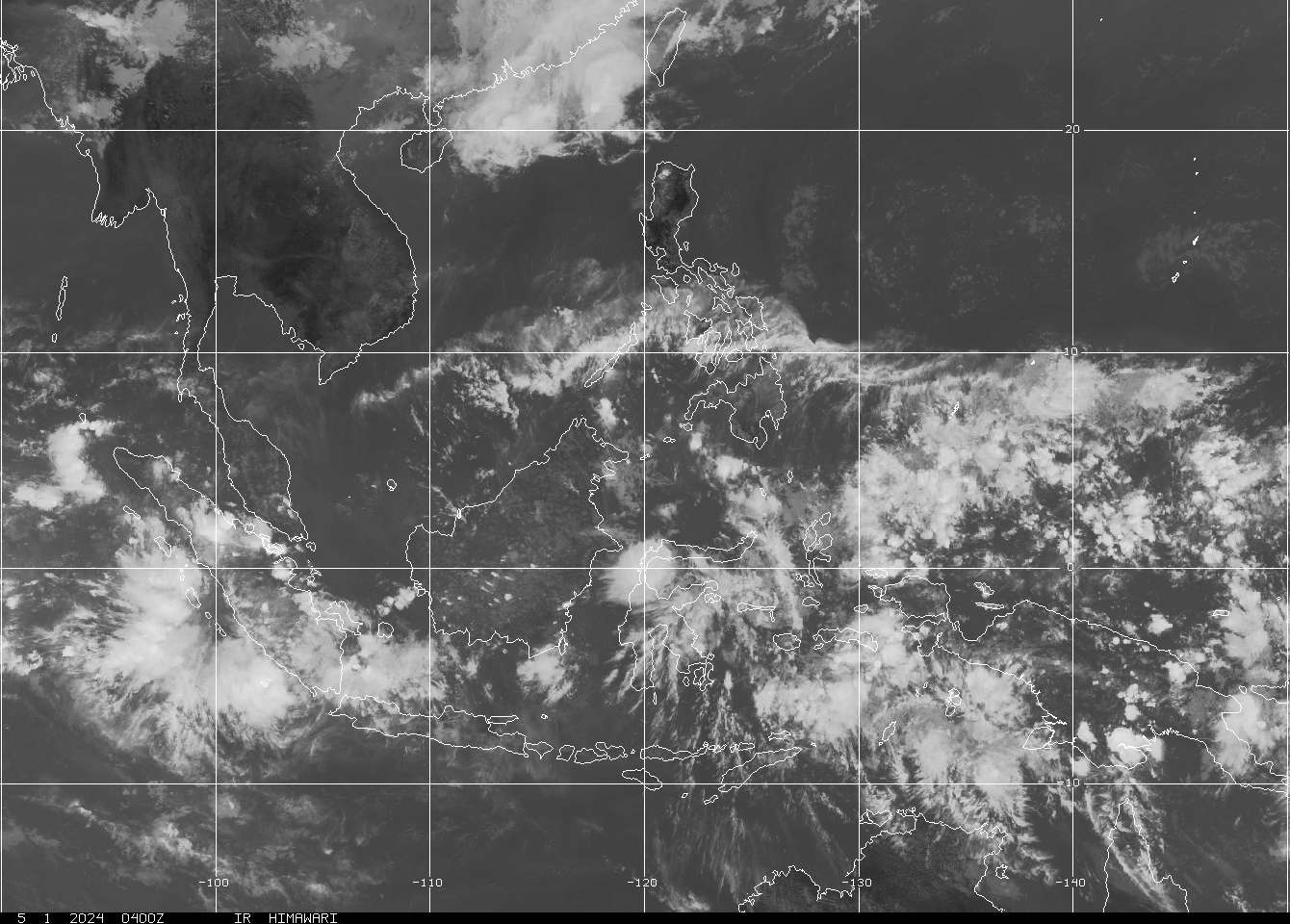
NWPAC outlook, 30 AUG
NORTH
The big story in the north region is Typhoon 12W LIONROCK, which has northern Honshu Island of Japan in its sights. The system continues to lose its steam due to various unfavorable conditions, and will continue to weaken through the remainder of its life-span. LIONROCK is expected to make landfall somewhere near Sendai as a tropical storm-strength system, and track quickly across the island and into mainland Asia somewhere near the Russia-China border sometime tomorrow. Heavy rain, gusty winds, and even a few landslides are possible in parts of northern Japan as the system blasts through. Elsewhere across the region, an early-season cold front has swept through much of the north region, backing temperatures down off of the very high readings of the previous 2 weeks. Temperatures will reflect an autumnal feel in Mongolia, while everyone else will just see some relief from the heat. Aside from the stormy weather in northern Japan, we will see some showers in Tokyo, and thunderstorms in southeastern Russia, but everyone else will see good conditions this afternoon.
| City |
High/Low C |
High/Low
F |
Conditions |
||
| Ulaanbaatar |
21 |
7 | 70 | 45 |
Partly cloudy |
| Vladivostok |
26 |
19 | 79 | 66 |
Thunderstorms possible |
| Beijing |
31 |
18 | 88 | 64 |
Partly cloudy |
| Seoul |
26 |
17 | 79 | 63 |
Partly cloudy |
| Tokyo |
29 |
23 | 84 | 73 |
Scattered showers likely |
| Xi’an |
31 |
21 | 88 | 70 |
Partly cloudy |
| Shanghai |
30 |
22 | 86 | 72 |
Mostly fair |
CENTRAL
The weather in the central region has cleared out for the most part, with relatively normal temperatures expected today. A few afternoon showers and thunderstorms could pop up near Hong Kong, and over the high country of south-central China. Otherwise, it will be a fine day across the region with lots of sunshine.
| City |
High/Low C |
High/Low
F |
Conditions |
||
| Kunming |
24 |
17 | 75 | 63 |
Scattered thunderstorms possible |
| Hong Kong |
31 |
27 | 88 | 81 |
Scattered showers possible |
| Taipei |
32 |
24 | 90 | 75 |
Mostly fair |
| Naha |
30 |
27 | 86 | 81 |
Mostly fair |
| Hanoi |
32 |
26 | 90 | 79 |
Partly cloudy |
SOUTH
Aside from the general deep tropical moisture that remains locked over the south region this time of year, it will be a relatively quiet day across the south region as well. 12W LIONROCK has exited the scene far to the north, and has taken much of the excess moisture and energy with it. We do have one weak trough over northern Luzon in the Philippines, which will fire off some spots of heavy rain over the northwestern provinces of the island through the day. The rest of the region will see the usual dose of afternoon showers and thunderstorms as the moisture in place gets a lift from the intense afternoon sun.
| City |
High/Low C |
High/Low
F |
Conditions |
||
| Siem Reap |
32 |
26 | 90 | 79 |
Thunderstorms likely |
| Ho Chi Minh |
32 |
25 | 90 | 77 |
Thunderstorms likely |
| Manila |
31 |
26 | 88 | 79 |
Scattered thunderstorms possible |
| Davao City |
32 |
24 | 90 | 75 |
Scattered thunderstorms possible |
| Brunei |
33 |
24 | 91 | 75 |
Thunderstorms possible |
| Singapore |
31 |
26 | 88 | 79 |
Thunderstorms likely |
TROPICS
As the M.J.O. phase enters a decidedly non-active phase, we find much of the activity and moisture absent from the tropics today with only Typhoon 12W LIONROCK to watch as it moves into northern Japan later today.

TAAG, 30 AUG
Typhoon 12W LIONROCK is spinning around to the east of Japan, and is expected to continue to track in an arc to the NW and across the northern half of Honshu in Japan later this afternoon. The system is expected to continue to lose strength as it enters cooler SST’s (Sea-Surface Temperatures), and increasing VWS (Vertical Wind Shear), with the final gut-punch coming as it makes landfall later. The system is expected to track quickly across Japan and into mainland Asia near the China-Russia border sometime tomorrow.

12W full, 30 AUG
Elsewhere across the tropics, there are no official areas to be concerned about as it has gone stone-cold quiet out there. Deep moisture and scattered pockets of energy will help bring a chance of afternoon showers to most locations; however, coverage is not expected to be significant.
| City |
High/Low C |
High/Low
F |
Conditions |
||
| Guam |
31 |
26 | 88 | 79 |
Thunderstorms possible |
| Yap |
31 |
26 | 88 | 79 |
Scattered thunderstorms possible |
| Palau |
29 |
27 | 84 | 81 |
Scattered thunderstorms possible |
| Chuuk |
30 |
26 | 86 | 79 |
Partly cloudy |
| Pohnpei |
29 |
21 | 84 | 70 |
Scattered thunderstorms possible |
| Majuro |
29 |
27 | 84 | 81 |
Scattered thunderstorms possible |
| Wake |
29 |
27 | 84 | 81 |
Thunderstorms possible |
Have a terrific Tuesday!
Courtesy: CIMSS, Tropical Tidbits, JMA, JTWC, Intellicast, WUnderground.com, N.R.L., RAMMB-NOAA
==================================================================
Disclaimer:
By making use of any information on this website, you agree to the following:
NO WARRANTIES: All of the information provided on this website is provided “AS-IS” and with NO WARRANTIES. No express or implied warranties of any type are made with respect to the information, or any use of the information, on this site. Westernpacificweather.com makes no representations and extends no warranties of any type as to the accuracy or completeness of any information or content on this website.
DISCLAIMER OF LIABILITY: Westernpacificweather.com specifically DISCLAIMS LIABILITY FOR INCIDENTAL OR CONSEQUENTIAL DAMAGES and assumes no responsibility or liability for any loss or damage suffered by any person as a result of the use or misuse of any of the information or content on this website. Westernpacificweather.com assumes or undertakes NO LIABILITY for any loss or damage suffered as a result of the use, misuse or reliance on the information and content on this website.
USE AT YOUR OWN RISK: This website is for informational purposes only. The opinions expressed within this website are the opinions of each contributor. Westernpacificweather.com urges you to consult with OFFICIAL sources for information whenever you feel a threat is impending.
All rights reserved. © 2016 Westernpacificweather.com


Comments are closed.