By: Weatherguy Adonis

Adonis S. Manzan
Deep “Low” Ushers Bad Weather Across Japan, Korean Peninsula & Vladivostok
Iloilo City, Philippines, 23 April 2012, (1600Z)–Earlier on Sunday, 22 April 2012, a massive “Low” forges forward off the Yellow Sea, and into West & Southern Japanese Islands, bringing heavy rains and sporadic thunderstorms which has become severe in Naha, Okinawa and the Ryukus Region, and Muroto, just Southwest of Tokushima. The severe weather has also caused disruptions in transportation as dangerous conditions such as flooding potential and occurrence of “Tornadic” activity was not ruled out by the local authorities.
According to Japan Meteorological Agency (JMA), the deep “Low” Pressure system was causing windy conditions and rough seas, along the East China Sea and the Sea of Japan. The highest winds were recorded near Ryukus Islands, where based on ASCAT wind analysis, I have been observing that top winds have reached to 50 kt (92 km/hr) at most, with stronger gusts as the system continues to drape the Japanese mainland with much convective clouds, and trailing along with it was an active “Front,” anchored along another area of “Low,” just off Hainan Island, in China.
JMA has been issuing several watches on the severe thunderstorm activity affecting the Ryukus Islands, and some parts of Fukui Region, and in Tsuruga, where the agency has been watching a potential for a “Tornado,” of which they have been issuing a “Level 1,” advisory there since 1500-JST (0600Z/0200PM-PHL/MAL).
Heavy precipitation was being observed also especially along Naha, in Okinawa Island, and in Ryukus Islands, wherein rainfall accumulation has reached to 150 mm to 200 mm in just 2 hours of intense rainfall brought about by the system. There were no reports of damage to property or injuries associated with the storm in the region.
The storm has been especially slow in its track Northeastwards, but remains “Quasi-stationary,” at the moment along Vladivostok, the Russian Federation territory.

Fig. 1.0 "JMA's nowcasting precipitation at 1515-JST (0215PM-PHL/MAL). Image Courtesy: JMA, Text: Weatherguy Adonis."
High Pressure Ridge Pushes “Front,” To Dip South, New “Spring Storm” In Progress
The said “Front,” was being forecast to move through along the Okinawa Region within the next 12 hrs, pushing the “Low,” clear off Japan’s West and Central Prefectures by early Monday afternoon. Having said that, the “Front,” was being pushed ultimately Southwards by a dominant “Ridge of High Pressure,” that has been persistent for the last four (4) days along the East Chinese mainland, causing the spillage into the Northwestern periphery of Luzon and the Taiwanese Islands, in between Batanes Island Group and the Babuyan Channel to the North of the Philippines. This has been the reason for a surge of cooler air mass from the West Philippine Sea, a.k.a. “South China Sea,” which has been oscillating some thunderstorms across the Northernmost towns of Luzon, especially along Cagayan and Isabela Provinces to the East, and the grand Cordilleras Region to the Center of Luzon, flanked by Zambales to the West, and Manila in the farther South of it.
As the sweltering heat continues to take its hold across Southeast Asian Region, I have been positive in noting that in the coming 2-3 days, another “Spring Storm,” is forecast to head towards Eastern China, and through Tuesday or Wednesday into the new working week, the Korean Peninsula and Japanese coast could expect another round of severe weather and dipping temperatures especially in higher elevations, more specifically in Sapporo and Hokkaido’s Northernmost tip this week.

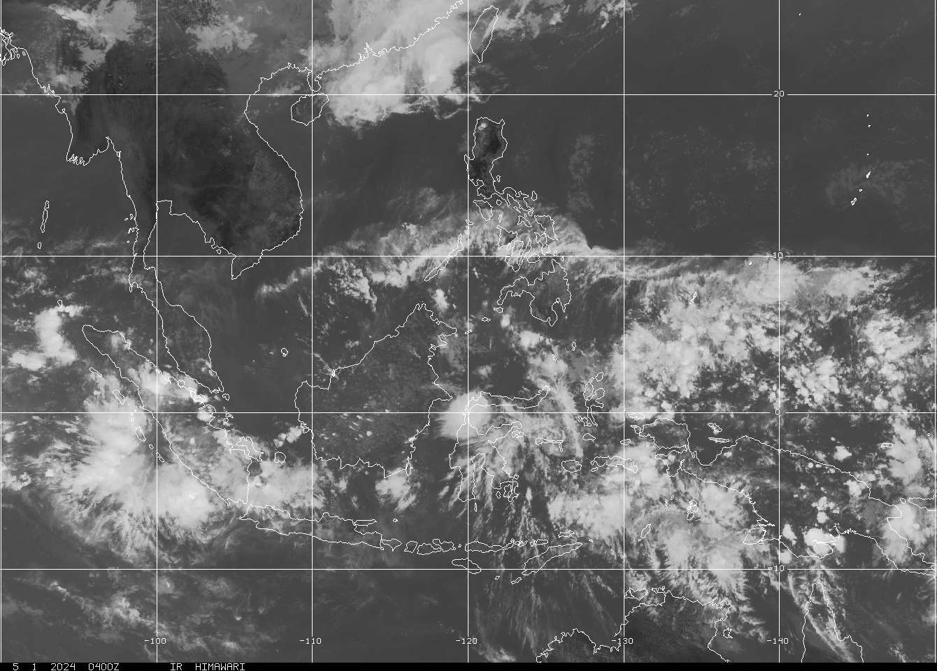
Fig. 2.0 "A graphical analysis I made to interpret more closely the weather situation across the Philippine archipelago at 1401Z (1001PM-PHL/MAL). Image Courtesy: NRL Mry, Text: Weatherguy Adonis."
Meantime, Hong Kong could yet again experience another week of severe weather as two (2) brewing storms off Central China has been developing for the last 24 hrs, and this could again spill some exceptionally supercharged atmosphere in the territory in the coming days, which the Hong Kong Observatory (HKO) has been closely monitoring its progress.
Flood Warnings For Mindanao, Scattered Thunderstorms Underway
The Philippine Atmospheric Geophysical & Astronomical Services Administration (PAGASA), based in Quezon City, Philippines has been issuing a warning on potential flooding along Mindanao, as the trailing effects of the Intertropical Convergence Zone (ITCZ), and the prevailing High Pressure affecting Luzon. This was being reflected in their 0900Z (0500PM-PHL/MAL) advisory on Saturday, 22 April 2012, which the agency did not made mention of a surging “Front,” emanating from mainland China, which could spell some respite from the searing heat that has yet jumped to 38.9C on the same day in Tuguegarao City, in Cagayan Province, and Manila sizzled at 36C, which are based on the highest reading that was obtained at 0700Z (0300PM-PHL/MAL).
Based on the runs that I have been focused on, the surging “Cold air,” mass from the mainland China, colliding with the “Warm front,” from the East of the country could spell the “Orographic lift,” that could spawn some localized thunderstorm activity and increase convection along the coastlines of Palawan, Southern Visayas and Mindanao, and also along the West Philippine Sea, just West of Southern Tagalog Provinces and the Greater Manila Area (GMA) later today.
I am positive on this because the odds are getting better for “Rain showers,” in spots across the country’s Western seaboards and the Eastern coast of Mindanao and Visayas, specifically in Leyte-Samar Provinces, too. We’ll see about it later today when it finally happens.

Fig. 3.0 "An ominous thunderstorm activity which I took photo of on Sunday, 22 April 2012, 24-ft high above the ground over Iloilo City, Philippines. Image Courtesy: Weatherguy Adonis."
The problem I was encountering for almost two (2) years now is the absence of PAGASA’s Doppler Radar Imagery, which I have been consistently been campaigning them to officially open the said facility to public access considering the fact that it was bound to serve the greater purpose of educating most of the 92-million strong Filipinos in the country. I really don’t know why the weather bureau hides it from public eye.
I am calling the attention of the current administration, being led by His Excellency Benigno S. Aquino III, of the Philippine Republic, to look into this matter and forge a better organization within the system that governs the country’s weather bureau, whom enjoys a very unpopular reputation amongst majority of its constituency–the Filipino people deserve more from PAGASA, no more slump in forecasting capability, but an empowered workforce, better equipped agency with a primordial duty to protect its citizenry from the adverse effects of climatic challenges of perennial storms and recurring droughts.
Also, I have been monitoring the situation over Luzon, the rest of Southern Tagalog Regions for the last 48 hours, since we got some welcome rains here in Iloilo City on Saturday night, 22 April 2012, coupled with intense thunderstorm activity and rolling thunder across the horizon that could be heard from afar.

Fig. 4.0 "Thundery rains could be seen from afar, as Cb clouds hang low beneath the base of a developing thunderstorm anvil just overhead Iloilo City. Image Courtesy: Weatherguy Adonis."
Malaysia Is Never Far
Based on the Global Forecasting System (GFS), a lot of tropical rainfall could be persisting especially along the near-Equatorial Regions of Asia-Pacific in the coming days, which include our fellow weather caster, Francis Chuah, from Kedah, Malaysia’s Northwesternmost Region is currently located.
Mr. Chuah has been reporting that at around 1300Z (0900PM-PHL/MAL), there has been lightning and some thunder rolling through the night sky, and as the night progresses further, at around 1545Z (1145PM-PHL/MAL), rains have finally fallen in his location. This was also confirmed by their Malaysian Meteorological Department (MalayMet), through Doppler Radar Imagery.
At the onset, there has been two (2) separate “Lows” affecting Malaysia Peninsula and Borneo, which could induce more tropical rains within the next 2-3 days in the forecast. Summer heat can become unbearable especially between early 0200Z (1000AM-PHL/MAL), and 0700Z (0300PM-PHL/MAL), which are mostly affecting the “Diurnal” episode of the convective processes of condensation and evaporation rate per area, that also would depend on the prevailing “Warm air,” and “Cold air” masses that collides which should provide an “Orographic lifting,” that provides the formation of Cb clouds, between low and high elevations. This process also allows the air masses to rise and cool down almost instantaneously as it generates “Humidity,” which result to “Precipitable” cloud formations, and on the most favourable of all conditions, it yields what we call, “Rainfall.”

Fig. 5.0 "A Doppler Radar Imagery of Malaysia Peninsula and Borneo indicating scattered tropical rain showers evidenced in the map. Image Courtesy: MalayMet."
Meantime, this has been your Weatherguy, hailing from the Philippines! =)
With data from NRL Mry, JMA, HKO, MalayMet, PAGASA and Westernpacificweather.com
(Note: If you have queries, email me at amanzan@smartbro.net or through weatherguyadonis@theboplive.net)


 May 2, 2012


